+7 (812) 328 9282 - Office, +7 (812) 328 9248 - Museum info@karpinskyinstitute.ru
Russian Geological Research Institute
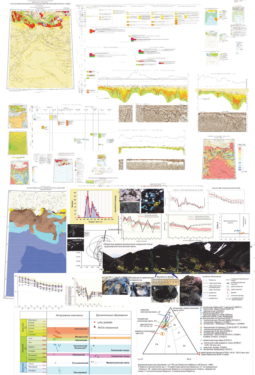
Our Institute, as part of implementation of the Rosnedra State assignment, compiled sets of the State Geological Map-1000/3 at 1: 1,000,000 scale, sheets O-55 – Talon and O-56 – Magadan. They cover the northern part of the Sea of Okhotsk and the Khabarovsk Territory, and the south of Magadan Region.
The main executor and coordinator of the work was the Department of Regional Geology and Mineral Resources of the Far East, involving experts from the departments of Regional Geology and Mineral Resources of the North-East, Northern Siberia, the OSL Laboratory, departments of Stratigraphy and Paleontology, and Regional Geochemistry. Experts from AO Dalmorneftegeofizika (Yuzhno-Sakhalinsk) made a significant contribution to the map sets compilation. They studied the water areas of the State Geological Map sheets. Laboratory and analytical studies were carried out in the Central Laboratory (ICP-MS) and the Centre of Isotopic Research (U-Pb SIMS SHRIMP-II, isochronous Re-Os) of our Institute. RAS Academician A.I. Khanchuk and RAS Corresponding Member V.V. Akinin provided advisory support.
The third generation of maps in sheets O-55 and O-56 compiled in GIS format with accompanying databases represents a new geological mapping information basis at the federal level, ensuring the development of a unified information space in mineral management. The maps reflect modern ideas about the geological structure and metallogeny of the Northern Okhotsk region and the adjacent water area. The basis was a comprehensive analysis of geological, geochemical, geophysical (including seismic) and remote sensing data using the laboratory and analytical studies of rock material collected during field work.
We obtained the following major results:
1. The volume of terrestrial volcanics of the Okhotsk-Chukotka volcanic-plutonic belt, the age of which, according to new data, is determined to be Late Cretaceous, has been significantly reduced. For the first time, the marine origin of a significant part of the Late Jurassic-Early Cretaceous volcanogenic sedimentary formations in the northern Okhotsk Sea region, previously considered continental, has been proven.
2. Based on modern isotope geochronological determinations and new marine microfauna finds, the age of the Uda-Murgal volcanogenic belt and the Koni-Pyagina paleo-island arc system has been reliably substantiated.
3. Igneous formations are divided into complexes. For the first time in the northern Okhotsk Sea region, the Hauterivian-Aptian granitoids have been found. The Albian-Cenomanian granitoids of the Magadan complex with a magmatism peak of 100 million years, formed in a geodynamic setting of collisional compression at the boundary of plate sliding are most widely developed. We determined a metallogenic orientation of granitoids of the Magadan plutonic complex for molybdenum-copper-porphyry mineralization and assessed their potential ore content.
4. Promising ore clusters Motykleysky, Chistoozerny and Pavlovichsky, oriented for copper-molybdenum-porphyry mineralization, have been identified. A predictive estimate for P3 category resources for ore gold, copper, molybdenum, and silver was given, and further large-scale geological studies were recommended in the area of these clusters.
5. For the first time, maps at 1:1,000,000 scale were compiled for the water area in the sheets – geological, Quaternary formations, mineral resources, lithological surface of the sea bottom, forecast for oil and gas, as well as accompanying diagrams – tectonic, deep structure, metallogenic zoning and minerals forecast, geomorphological.
6. For the water area in the sheets, hydrocarbon raw materials within the North-Okhotsk, Shantar-Lisyansk, Tinrovskaya, and West Kamchatka oil and gas prospects of the Okhotsk petroleum province were assessed. The Oiran-Temlovskaya and Krutogorovskaya promising petroleum accumulation zones were mapped. We made a resource assessment of petroleum prospects based on the specific density of the initial total geological resources.